Saturday, August 3, 2013


Delivery to Gillette, WY 

   On a hot, humid, sunny June day we picked up a Winnebago Sightseer in Forest City and headed west past very wet fields.  Water is sitting in ditches and low areas in the fields after our steady rains the last few weeks.  Farmers were working ground around the wet spots to get the crop in. 

  Traffic on Interstate 90 us light compared to Interstate 80 which is our usual route.  Windmills are scattered all over this area of Minnesota.  Southwest Minnesota was described as a "sea of grass" by the early Prairie Schooner travelers headed west!   

    In and out of clouds and sunshine as we cross into South Dakota.  Past Sculpture Park with the world's largest bull's head.  From flat farm land into rolling hills covered with grass.  Herds of cattle grazing in tall grass with their calves nearly hidden.  Large blue ponds of water reflecting the blue sky.  Hay being baled.  The silhouette of grain elevators in the distance with rail road cars parked for loading.

    Past the exit to De Smet, which is one of the homes of Laura Ingalls Wilder.  Our daughter and several granddaughters would love to spend some time there! 

    Listening to Lee Kline's Iowa Notebook getting a chuckle and a remember when as we put on miles. Also  Providential Battles by William Potter who provides a providential interpretation of twenty of the greatest military battles in the world.

    The highway runs along the bank of the Missouri River.  Lewis and Clark traveled here.  The Rest Area with scenic overlook is a great place to stop and stretch and learn some history of the area.

     Across the river and climbing the hills that will lead into Wyoming. Passing signs advertising all the "tourist" stops available.  We counted at least 100 antique fire engines beside that many signs for the Fire House Brewery!!

      Acres of farmland spread out over the rolling hills.  Some were being planted.  Rows of trees planted as windbreaks looked like someone making pencil lines on a quilt of brown and greens.  Ranchers on horseback herding cattle.  A semi-flatbed with rolls of wire parked along the gravel road near where ranchers were making fence.  An ATV was used to move the rolls of wire.  We can see the edge of the Badlands from the highway.

      Big blue/black clouds never dropped rain all afternoon as we drove under and around them until about 10 PM!  The wind and hard rain rocked us to sleep that night!

      A hazy, cloudy morning with a blanket of fog of the pine tree covered hills transition into rocky grass covered hills, wide valleys and mountain tops on the horizon as we cross into "Big Sky" Wyoming.  Areas of blue sky are allowing the sun rays to highlight the buttes and low mountains ahead.  What a contrast!  The palette of greens is changing from lush deep greens to a lighter shade due to dryness of the area.

     Through the windshield:
  • Small groups of antelope grazing.
  • Herds of black Angus cattle grazing. 
  • Small ranches scattered through the valleys with exits to "Ranch Roads."
  • Trees lining the meandering creeks.
  • Rows of wooden snow-fences stand at attention holding the line prepared for the snowy battle to start. 
  • Oil wells scattered along the valley.
  • Long trains with coal filled cars.
  • Mining machinery sitting in lots along the highway.
  • Storage tanks scattered between oil wells.
  • A coal mine with conveyors to power plant.  The gully dug deep showing the black vein of coal to be mined and loaded on the conveyors.
  • Iris and lilacs are just blooming in the yards of Gillette.
Delivered motor home to the grounds of the FMHA (Family Motor Home Assoc) show on the edge of Gillette.  Headed back east and stopped at a Rest Area along the Belle Fourche River.  Ate our dinner in the shade of some huge cotton wood trees.

    Took exit 153 to go to the Devil's Tower, but stopped in the town of Moorecraft and visited the West Texas Trail Museum

    History:  In 1866, the first herds of longhorn cattle were trailed from Texas through Wyoming and into Montana, a 1700 mile journey.  At its peak in 1844 it was estimated that 800,000 cattle were coming north past the dry areas in the south.  The Belle Fourche River was a welcome sight.  The last major stop before being driven further north.
       In 1887 Jacob Kaufman saw his chance to make some money off the weary cowboys by operating a store/saloon at this stop.  It served as a stage stop and post office for a mail run between Buffalo, WY and Spearfish, SD.  The inspector for the post office didn't like how the mail was being handled and moved the office to the AK Ranch.  Stocks Miller ran this office and named it Moorcroft after his home town in Scotland!
      The CB&Q Railroad laid its tracks east of this spot in 1891 following the Texas Trail route and had Moorcroft as its northernmost point.  This was perfect for laarge ranches to ship cattle via the railroad.

Museum Facts and Highlights:

  •  For a perspective: In 1894 there were 32 trail herds each with 4,000 head.  Each herd stretched 2 miles long and 1/2 mile wide.
  •  In 1866 Mr. Nelson bought 600 cattle for $10 each, drove them 1500 miles north on the trail and sold them for $100 each!
  •  The Texas Longhorn originated in South Texas as a cross between cattle brought from Spain and cattle from the European/American settlers. The are known for their long horns and hardiness in the harsh weather conditions.  Their long and lean structure allowed them great stamina for traveling the trails.
  •  The demand for more cattle was the result of more settlers, explorers, entrepreneurs and the killing of the bison.
  •  Branding was important to prove ownership of cattle.  Branding was started in 1541 when Cortez brought animals to the New World from Spain.  They were branded with 3 crosses.  There are 3 ways to read a brand: from left to right, from top to bottom, and from outside to inside..
  •  A cowboy would have a pair of woolies--sheepskin chaps, hat, spurs, knife, branding irons, rope and quirt
  •  A shave and a haircut was six bits--75 cents!
  •  A 10 ft handles on a magnesium bakers peel that was used to insert and remove baked goods from an oven.
  •  An oak roll top desk ordered from Sears in 1814.
  •  Family histories of pioneers, collection of quilts & sewing machines.
  •  Railroad items and photographs from the CB&Q (Chicago Burlington & Quincy).
  •  Western saddles and tack.
  •  A complete cowhide.
  •  A display of the Empire Sheep Ranch owned by the Guthrie Family.   They owned 20,000 acres and 55,000 sheep at a time when open range was dominated by the cattle industry.  Yes, the display shows newspaper articles of cattlemen trying to run off the sheep herders!  Remind you of the song about the cattlemen and the ranchers in "Oklahoma?"       Mrs. Guthrie ran the ranch after her husbands death.  After supper she would line up bottles on a fence, take her gun and practice her shooting.  This would let all the men working for her that she was capable of handling a gun.  It was rumored that she carried a lot of money in her big hand bag and a gun.  Since she was often alone she had a gun near her at the ranch at all times. She was known as a shrewd and competent rancher. 
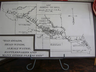


  •   A map and information about the bicycle trip by soldiers from Missula, MT to St. Louis, MO.  "On June 14, 1897 the Bicycle Corps of the Twenty Fifth Infantry USA left Missula, MT to determine if the bicycle could be used in warfare of the future!  Other countries were adopting it as  component parts of their armies," stated the newspaper article.  You can watch a complete program on Montana PBS website!


 Devil's Tower
       Following the river north and east the highway curves through rocky ledges and pine forests with open grassland being grazed by flocks of sheep. 
The tower rises up 865 feet. It is actually the exposed core of a volcano. The sides are made up of thousands of small columns. The rocks and boulders around the base that are broken pieces of columns having fallen from the sides.  
      In 1906 President Teddy Roosevelt designated Devil's Tower as the nations's first national monument.  Today the park service has7.4 miles of walking paths and a visitors center.

Pender, Nebraska
     Out of mountains and pastures and ranches and into rolling hills covered with irrigated hay corn & bean fields, cattle feeding lots, and hog confinement buildings.  Nothing is flat! Even the irrigation rig curves with the hills.  A sea of grass--as the wind blows it waves!  Heading to Pender, Nebraska for an appointment at the Blue Ox factory to get our tow bar checked, cleaned and lubricated.
     The town is pretty.  Homes and business have outdoor quilt blocks with the quilt's name.  Pretty flowers.  Huge brick building on  main street, Palace Hotel, has several small shops at street level.  Nice city park.  

This time our schedules did not work for a visit with son and family so---Back to the Prairie!

Thanks for traveling with us,
Prairie Schooners 


Monday, June 10, 2013

Chattanooga, Tennessee

We are back on the road after dealing with health issues.   Interesting to note that back in January we were dealing with travel advisories due to snow & ice and now the travel advisory is for flooding!  We choose the main highways rather than county blacktops as we start south with light rain under a sky thick with clouds.

Rain makes for green grass and lush growth everywhere!  Blooming shrubs accent the fence lines. Acres of fields are neat rectangles of black dirt with rows of  tiny green corn plants emerging. Some have ponds of water standing in the lower areas.  Rivers are running bank full to overflowing.

 As we drive through the Mississippi River plain in Missouri we Listen to Christian historian, William Potter's, interpretation of twenty of the greatest military battles in the world.  Each altered the course of history and served strategic roles in the unfolding plan of God in earth history.

Interesting cloud formations, heavy showers with lightening, very windy with weather band radio issuing severe thunder storm warnings.

Thanking the Lord for a drive through St. Louis with no heavy rain!  

The farmers are stirring up dust clouds as they till and plant their fields in southern Illinois.  Many motorcycles, boats and campers on their way home from Memorial Day week-end or taking off on summer vacations!

Over the Ohio River (third large river today!)and into the Kentucky hill country with forests and lakes.  Crossing the Tennessee and Cumberland River on our way south to the Flying J at Oak Grove for an overnight stay.

Sunny and warm as we cross into Tennessee and head to Nashville. I-24 is a pretty drive through with tree-lined highway, mountain silhouettes on the distant landscape, wild flowers growing in the ditches and medians, acres of small fields on the mountain side  with fragrance of cut hay.

As we near Clarksville, TN the highway climbs the steeper peaks.  Shrubs with fragrant blossoms, perhaps honeysuckle, line the road.  Clouds make dark shadows on the  green slopes of the mountain peaks.   Huge lakes formed by the dams along the Tennessee River spotted with fishing boats.  Water running down off the mountain off the rocky ledges make miniature waterfalls.

Smooth and fast deliveryGood night's sleep and we are off to explore on our way back to the Prairie!

Stones River Battlefield--Murfreesboro, TN


Cannon at Stone's River Battlefield
 

A small part of the original battlefield is preserved.  There are short trails and a self-guided auto tour with markers identifying stopsThe museum has history of the town, the battle and reactions of the soldiers. The front page of an 1862 newspaper had a paragraph or two from every battlefield in every state.  And they did not even have the internet!!!  Go out the back door of the visitor center.  Look across the field where Union and Confederate soldiers fought.  Imagine opposing armies totaling 81,000 men battling to control Middle Tennessee in one of the Civil War's bloodiest encounters.

Union troops make their final stand here, defending the Nashville Pike and the railroad both vital lines of supply.  The scene as we looked out differs little from 1862!  The railroad and the pike are in the same place, and fields are now planted with native grasses between cedar thickets.  Split rail fences and cannon as well as a National Cemetery with small white headstones standing in perfect rows and the sound of trains and traffic mingled with the songs of birds make a battle seem very unreal!

Why Stone's River?
As 1862 drew to a close, President Abraham Lincoln was desperate for a military victory. His armies were stalled, and the terrible defeat at Fredericksburg spread a pall of defeat across the nation. There was also the Emancipation Proclamation to consider. The nation needed a victory to bolster morale and support the proclamation when it went into effect on January 1, 1863
The Confederate Army of Tennessee was camped in Murfreesboro, Tennessee only 30 miles away from General William S. Rosecrans’ army in Nashville. General Braxton Bragg chose this area in order to position himself to stop any Union advances towards Chattanooga and to protect the rich farms of Middle Tennessee that were feeding his men.
Union General-In-Chief Henry Halleck telegraphed Rosecrans telling him that, “… the Government demands action, and if you cannot respond to that demand some one else will be tried.”
On December 26, 1862, the Union Army of the Cumberland left Nashville to meet the Confederates. This was the beginning of the Stones River Campaign!

The River Discovery Center--Paducah, KY


Riverfront at Paducka, KY


William Clark of Lewis & Clark fame founded Paducah in 1827.  It's origin and prosperity is attributed to its strategic location at the confluence of the Ohio and Tennessee Rivers. You can actually see the blue of one and the green of the other as they merge when you walk along the waterfront. Murals depicting its history are painted on the flood control retaining wall along the banks of the river.  One mural shows a special horse & dog well that was installed on main street in the early days!

The River Discovery Center is housed in downtown's oldest standing structure.  The exhibits highlight the history and habitats of the region.  One side of the building houses a training center for riverboat pilots.  The upstairs was the home of a banker and has furniture and items from that era.

The pilothouse simulator lets you pilot a tug, a speedboat and a coast guard buoy tender through various scenarios.   Yes, you can make yourself or your passenger sea sick!!

Did you know that a fish is the host for the fertilized egg of the mussel or clams as we know them?

Steam-powered "snag boats" were outfitted with a huge, strong claw that could take out tree trunks to clear the river for the boats.

The steam calliope patented in 1855 by Josh Stoddard was named after the Greek goddess of music. It was originally intended to replace church bells, but had a less than pious sound to 1855 New England church goers!! It looked like it was a failure, but his brother, who was a river boat captain recognized the potential of the ear-splitting instruments use to announce the arrival of steamboats!!

Two of the most interesting riverboat captains listed were T.G. Ryman and May Miller.
Captain T.G. Ryman is one of Nashville’s favorite sons. He was a well-known Riverboat Captain on the Cumberland and Tennessee Rivers, and by the mid to late 1880’s Captain Ryman owned a fleet of 35 steamboats. Captain Ryman was changed after attending a tent revival being conducted by evangelist Sam Jones. As a result of religious conversion, Captain Ryman began construction of the Union Gospel Tabernacle in 1889. The huge building was completed in 1891 and it became one on Nashville most recognizable building. After his death it was named The Ryman Auditorium! 

Captain May Miller, daughter of a steamboat engineer was born in 1846 in Louisville, KY.  In 1865 she married Captain George Miller of Portland, KY, a respected river man and carpenter at the Howard Shipyard in Jeffersonville, IN.
The Millers shared the functions of operating the steamboat, Saline, carrying passengers and freight on the Mississippi, the Red River and the bayous of LA.  She became the first female steamboat Captain to receive a Steamboat Masters license in the US!

Great River Road & Southern Lincoln Heritage Trail

Off the Interstate driving west on state Hwy 146 through rolling rural country side.  Huge trees line the road alternately with acres of wheat fields, pastures, cornfields and farm buildings.  Small churches and cemeteries dot the countryside.  Huge blooms on the catalpa and magnolia trees as well as peonies, roses and lilies make a colorful landscape.  Past the Lincoln/Douglas Debate site at Jonesboro, IL and north on Highway 3, the Great River Road beside the Mississippi River.

We  continue to meander through flat areas of farmland, small farms, recreation areas, small towns, forests of tall trees occasionally a glimpse of the river, tugs, barges, unloading terminals with truck traffic and the rocky, tree lined slope of the opposite bank.

Chester, IL is the "home of Popeye!"  Cement Popeye figures and his cartoon friends are spotted sitting all over the town as well as murals painted on the sides of buildings.

Following a sign north of Chester to  The Pierre Menard Home we take a break and find an almost hidden gem along the river bank,

Pierre Menard Home

A small French Colonial home was built for trader Pierre Menard, who later became Illinois first lieutenant governor.  He was born in Montreal, Canada and age of 15 signed on with a trading expedition to the Illinois Country establishing his own trading business.

An earthquake changed the course of the Mississippi and Kaskaskia river leaving the town on an island separating it from his home.  It is in Illinois but can only be accessed by a road in Missouri!

Interesting discoveries on the tour of the home: 


Rope springs and tightner


  • 200 year old carpets that were hand made.  You can see the stitching on the back. 
  • "Sleep tight. Don't let the bedbugs bite!"  To sleep tight the ropes that make up the springs under the mattress needed to be tightened.  A wooden tool to do that.
  • Small 2 shelf corner stands that held the wash bowl and pitcher.
  • A built-in round cement sink in the kitchen and a small bread baking oven built in the wall beside the fireplace.
  • The center entrance hall was used to entertain by setting up tables the full length of it.
  • Back of handmade rug
  • Being able to "touch" items.


Back on the road headed north to St. Louis and then more rain all the way into Iowa.

Some time with family and back on the Prairie where the lawn does need mowing and the garden does need weeding!

Thank-you for traveling with us,

Prairie Schooners


Tuesday, March 19, 2013

Destination: Baton Rouge, Louisiana

It was a dark, cold, windy, winter morning in early February when we left the Prairie to deliver a little VIA Winnebago to hopefully the warm southern city of Baton Rouge, Louisiana.  The sun rises as a big red ball starting a light show of reds, pinks and mauve against a blue sky.  A layer of snow covers the landscape until we drive over the Des Moines River and cross into Missouri.

Driving through acres of flat land waiting to be planted. The banks of the Mississippi River can be seen in the distance to our left.  Ganton is an interesting river town.  Large old houses sit on well-kept lawns.  Up and down the bluffs as we get closer to St. Louis.  The rock cliffs have icicles cascading in the areas not touched by the suns rays.  As you look across the brown landscape the green fields of rye or winter wheat make a beautiful contrast.  A taste green that  we will see further south.

Water sitting in the fields as we near the Arkansas border.  A result of all the rain and snow storms that have moved through this area this winter.  The Missouri Welcome Center near New Madrid has displays with information on earthquakes.  This is an "epicenter" for quakes!  

Across the Arkansas border and counting down the miles to the Flying J in West Memphis.  Will there be an Elvis sighting tonight?    A second spectacular light show on display for us as the sun sets.  A big red ball settling behind the horizon leaving behind changing colors blending against the blue sky!   Thank- you, Father God, for sharing your amazing creativity!

A foggy morning drive through Memphis in the dark, over the Mississippi River. But clear e In and out of fog. Was lost when we turned into Grenada, Mississippi to find some breakfast.  Thankfully, Gertrude, our Garmin, found the main road back to the Interstate.  WOW!  our view from the windshield went from foggy black night to clear technicolor day when the sun came up and burned off the fog!  Tall Southern Pines and the skeletal trunks and branches of the hardwoods line the highway as we head straight south down the middle of the state of Mississippi.

The grass in the ditches and median is green.  Daffodils, yellow flowers on the mustard plant and blooming forsythia bushes dot the landscape.  Acres of pine trees, all sizes.  Logging trucks.  Areas with cut tree trunks stacked waiting to be loaded and shipped to a mill.  We passed a Customs & Border Patrol boat being towed on a trailer.  It had four 300 HP motors mounted on the rear!  I believe it could move through the water way to fast to troll for fish!!

Cloudy and hazy, but 66 degrees as we cross into Louisiana counting down the miles to the dealer. Unit washed.  Dealer found. Quick check-in. Finished our  "tail-gate" lunch just as it started to sprinkle.

Capitol Park Museum

 The Capitol Park Museum is located along the bank of the Mississippi river beside the State Capitol building.  The museum has two floors with two permanent exhibitions.  
    Some highlights of the Grounds for Greatness:  Louisiana and the Nation exhibit:
  • France sold The Louisiana Purchase to the US in 1803 for 15 million or 4 cents an acre because Napoleon wanted to keep it out of British hands.  This area consisted of nine present day states and portions of 5 others!
  • The Port of South Louisiana between New Orleans and Baton Rouge, a 54 mile stretch of river , is one of the busiest ports in the world.  It is the nations largest in terms of tonnage handled.  The principle export, grain, accounts for more than 50% of country's annual shipments.  The largest import is crude oil!
  • Many people immigrated to US through this port, too.  
  • Memorabilia from the military role of this area in the 19th and 20th centuries from the War of 1812 and the Battle of New Orleans (remember the song??) through World War II. 
  • These people all lived or fought in this area:  Jefferson Davis, Gen Beauregard Jackson, Gen. Zachery Taylor, Muscian Louis Armstrong,  State Politician Huey Long, author Harriet Beecher Stowe, and Artist James Audubon.
  • Thought of the movie, "War Horse," when we saw the teeth saved from Gen. Beauregard's favorite horse!
  • Two trees are native to this area:  long leaf pine and bald cypress.  Both used by lumber industry
  • Industries: cane sugar, oil, salt, indigo, cotton, tobacco, rice and seafood.  A 50 ft. wooden shrimp trawler painted the typical colors turquoise & white and used until 2004 by a local family is an impressive exhibit.
  • We sat in a "fishing chair" that was used to catch a 1000 lb Marlin.  Huge lures were displayed
  • A "Go-Devil" engine that is used in the swamps. It's drive shaft goes straight out the back of the boat.
  • A  Civil War submarine that was found in Lake Pontchartrain.
  • An exhibit about steam boating.
  • Flatboats were floated down the Mississippi River by farmers to Natchez, goods sold, boats disassembled, sold as lumber, and  walked back north up the Natchez Trace.
Some highlights from Experiencing Louisiana: Discovering the Soul of America:
  • Cajin are descendents of the French Canadian (Arcadia) immigrants
  • Creole are descendents of slaves and some whites and speak a French dialect similar to what is spoken in the Caribbean
  • Baton Rouge means Red Stick.  A red pole adorned with animal bones was found at the site of this city.  It was probably a tribal boundary or an Indian "mourning" pole.
  • A trinity of veggies (onions, bell pepper & celery) are the basis for Louisiana  dishes. Cooks add these and garlic to a completed roux (browned flour in fat) as a foundation of their dishes!
  • A cure for Hansen's Disease or leprosy was developed at Carville, LA.  A sugar plantation was changed to a hospital for leprosy patients in 1894.  In 1941 Promix, a sulphone drug, was administered to the patients. The disease was controlled. Today, several drugs including sulphone make up the regime for the disease.
  • A Maradi Gras Gallery featuring the elaborate  costumes worn.
  • A "Po-boy" sandwich is made with fried bread filled with fried seafood, smoked sausage, meat balls, or roast beef and gravy.
  • Red beans and rice was a typical meal on Monday, washing day.
  • Think Gumbo, Jambalaya and Pralines or Crayfish, Oysters, Seafood Boils & Crocodile!
  •  A Christmas tradition  was building bonfires along the banks of the Mississippi River to light the way for Papa Noel, French for Santa Claus.
  • Spanish Moss is gathered,cured and ginned in a "Moss Gin."  The gin removes dirt and twigs,  separates the outer coating from the inner fiber and straightens the moss strands making it ready to be sold commercially.
St. Francisville, LA

   It is late afternoon.  We are driving north on Hwy 61, named the Great River Road, in the drizzle. On one side of the road we drive  past the Port of Baton Rouge with acres of oil storage tanks, refineries, chemical manufacturing plants along the bank of the Mississippi river.  Pine trees interspersed with cleared areas for homes, small business and grassland pastures with lakes on the opposite side of the road. 

    It is dark with a steady rain when we get to St. Francisville. The Best Western along the highway was full for the night. A bed and breakfast needed advanced reservations but driving through the pine trees we find the Magnuson Hotel.  The management tells us they have two alligators in the canal behind the motel.  Our room is on that side!  The alligators are only seen in the early evening when the caretaker feeds them.  But you park in front of the hotel and walk through to your  room in the back!  We did not see them.

   In the morning it was cloudy, but no rain!  We drove through the town finding the street with the historic houses.  Each house had a sign  along the street with the type of architecture and history.  Most are private residences.  Roses, azaleas, iris and magnolias are blooming under the huge oak trees with hanging moss. Some were decorating with purple, green, gold and wine multicolored swags for Mardi Gras.  Little shops like Grandmother's Buttons beckoned me, but they were closed. An Episcopal Church and the Court House were shelled during the Civil War. Bayou Sara was a trading post on the banks of the Mississippi River.

    Along the highway are Antebellum homes and plantations.  Each has a long lane winding under the canopy of low, thick, spreading branches of oak trees. Tall spires of pines.  The tall hardwoods have fuzzy green branches as new leaves are showing.  Cypress trees with their rounded knobby knees stand in the swampy areas.

Windsor Ruins
    Crossing into Mississippi the Highway 61 changes to The Blues Music Highway.  Markers along the way tell the stories of men and women and how the places they lived influenced their music.  We pass acres of pecan trees, blueberry farms and the entrance to the Natchez Trace.  The sun comes through the clouds as we drive through Natchez. 

     A sign points to the Windor Ruins exit.  A two-lane blactop curves through the back country. Huge gulleys, a result of continuous crops of cotton planted on the loose sandy soil by the plantation owners have eroded in the rolling land. Kudzu vines and moss covered trees line the road. The sun makes interesting designs as its rays shine through the leaves and branches.

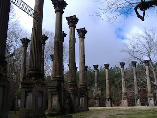
   Twenty Three tall fluted columns with iron Corinthian capitals stand as silent sentinels in the forest to remind us of what had been! In 1849 Smith Coffee Daniell II, who was born in Mississippi in 1826, the son of an Indian fighter turned farmer and landowner married Catherine Freeland.  They had 3 childrenThey built a large mansion on the 2600 acre Windsor plantation in 1860.  He only lived in the mansion for a few weeks before he died at the age of 34.  The mansion survived the Civil War. It was used as a Union hospital and observation post sparing it from being burned by the Union troops.  After the Civil War, during a house party on February 17, 1890 a guest left a lighted cigar on the upper balcony and Windsor burned to the ground destroying everything except 23 of the columns, balustrades and iron stairs!

Vicksburg, MS

   Vicksburg is built on the hills along the banks of the Mississippi River. Barges are pushed down the river past the city. Cannons are everywhere reminding us of the Civil War battle that was waged in this town.  If you tour the homes they will show you holes made by the cannon balls.  We had driven through the battlefield park on the edge of town on a previous trip so we chose to visit the Old Courthouse Museum.

Old Courthouse Museum 

     The building is considered the finest antebellum structure in Vicksburg. It stands on one of the highest hills in the city taking up an entire city block. On the grounds a local planter, Jefferson Davis, launched his political career and from the clock tower Union troops raised the Stars and Stripes on July 4, 1863 signifying an end to the 47 day siege. 

      It has nine rooms filled with artifacts and displays of the history of the area. The Court Room on the top floor features an ornate cast iron judge's dias and railings.  The doors and windows are 11 feet tall.  The doors on all four sides open to balconies to create a cross draft to cool the 14 foot ceilings in the room.


Highlights of the nine rooms:

  • A room of antebellum clothing including wooden soled dancing shoes.
  • The word "Dixie" comes from a $10 bank note printed by a Louisiana bank.  It was printed with a 10 and a X.  In the center printed in large capitol letters DIX which is French for 10.  The term "pocket full of Dixies" was used to indicate being rich!
  • In 1884 Phillip Gilbert Sr  was the first shoe dealer in the US to adopt the idea of putting each pair of shoes in a separate box for sale to his  customers. Many of his shoes were of soft kid leather imported from France.  Wrapping them individually in boxes kept them from being scuffed!
  • A Beaten Biscuits Machine from 1900.  Dough runs thru rollers 100 times to roll them.  An 1850 cookbook stated: "to mold it again and again and again and roll it thin..."
  • What are Beaten Biscuits?  Before the days of baking powder and baking soda pearlash was used to leaven the biscuits.  It gave them a bitter taste, but by pounding and folding without pearlash, tiny air pockets formed in the dough.  When the biscuits were baked the air pockets expanded and caused the biscuits to rise without the bitter taste!
  • Pieces of sheet music in hard bound book form.
  • Coca Cola was first bottled in Vicksburg in 1891.
  • The displays are in beautiful antique wooden hutches.
  • A soldier would carry a box of lead weighing 15 or 20 lbs to melt down over campfire and molded into shot for his gun
  • Civil War caltrops: an iron devise looking like "jacks" with sharp points.  When thrown would land with 3 points upwards.  An enemy horse that stepped on one was instantly lame.
  •  The newspaper was printed on the back of wallpaper during the siege in 1863. The last edition dated July 4th has an added note by the Union soldiers who found the type set.
  • The USS Cairo, an armored gun boat was sunk in the Yazoo River north of Vicksburg.  It has been raised and put in a museum.  We have visited it in the past.
  • While Vicksburg was under martial law for 2 years the citizens were required to sign a loyalty oath to the US.  If refused to do so could not get permits to go in and out of town, not even to the cemetery for a funeral. Their plantations were given to Union speculators or occupied by soldiers.
     Back on the road driving north under a sunny blue sky with huge white fluffy clouds.  Acres and acres of flat farmland some with ridges for planting cotton.  Airplanes swooping overhead as they spray. A bear crossing sign! Tractors in the fields planting. Grain elevators. Farmsteads (called plantations) Groves of trees. Small towns. Acres of pecan trees. Cotton pickers and balers stored for the winter in open sided metal sheds.  Grain bins.  Tall electric poles march across the fields connecting lines for moving power from power plants along the Mississippi River.  Many trailer parks. Cotton gins.  A rice mill.


    North and west retracing our route back to Iowa and snowbanks! 
    Thanks for traveling with us!
     Prairie Schooners