Saturday, November 12, 2011

To Thorndale, Ontario in November

Rainy, windy trip
This was a "bland" unit! White with beige swirls outside, all beige inside! It was sold and would be picked up in Ontario and driven to colorful Florida for the winter.
We headed east on a rainy, windy early morning with a winter advisory for the next day here in Iowa.
The wind gave us a rough ride. Clouds kept the rising sun from our eyes. Had to endure my "pet peeve"---The wind shield wiper only clears 1/2 of the passenger side window! My line of vision is divided with clear and raindrops.

Rainy days make sunny days so much more precious!
Cloudy and 56 degrees as we head through south Chicago and into Indiana.
On I-94 east to Detroit. In the distance steam is rising from smokestacks on the factories along the lake.
A call to our broker at the border confirms that paperwork is at the border. That makes for a quick smooth crossing.
Still some
leaves with color. Enough color to accent the bare branches and green pines
Into Michigan, searching for a safe place to park this "elephant" for the night. Thankful that we have driven out of the rain. A Super Walmart in Battle Creek. A long walk around the s
tore and the parking lot. A great steak burger at Steak & Shake. A clean diner with friendly servers who really seem to enjoy working together. A good night's sleep.
The rain stops as we near Detroit in the morning. Followed the signs to the Ambassador Bridge into Windsor Ontario. Major construction on the bridge. Signs say "follow signs do not follow your GPS!"

Readjust for Canada:
  • km instead of miles.
  • signs are both French and English.
  • gas sold in liters instead of gallons (price was about $4.50/gal).
  • highway numbers are printed on a crown. Roads and towns have very definite English sounding names: Thames, London, Queen's Road, etc.
Light rain and winds as we drive on Hwy 401 East toward London.
Acres of flat farmland interspersed with farmsteads.

Some fields have been harvested and tilled, some still have standing corn and soybeans waiting for the combine. Combines were running in the rain.
Large windmills with blades turning are scattered across the horizon in all direction for many miles.
This area of Ontario is like an island between Lake Erie on the South and Lake Heron on the North. A short drive either direction and you will be on the coast.

Past the exit to Leamington, the tomato capitol of Canada. Another season we would be driving past acres of tomato plants.
Acres of solar panels beside the industrial section of Tilby.
Trucks, trucks, trucks carrying "stuff" both directions. Lots of containers & new cars.
Yeah! So
me blue sky ahead!
Nice service centers/rest stops. Each has a sign a couple miles before the exit that s
tates in French & English: Fatigue Kills Take a Break
Arrived at the dealer in the rain, unhooked & unloaded in the rain, quick check-in, and heading back west in a downpour all the way back to Windsor.
Yeah! blue skies can be seen ahead!

Back through the construction obstacle course of orange pylons, through customs, over the Ambassador bridge, pay toll and head into Detroit traffic.
We heard that the Republican Presidential Candidates were in the area for a debate tha
t evening, but did not see them nor any of the "occupiers."
Very strong winds that howled around the corner of our motel in Jackson, Michiga
n all night.
Scraped ice from windshield the next morning before continuing west through Chicago and into Iowa with cold wind and partly cloudy sky, but thankfully no rain!

LeClaire, Iowa
A quick lunch
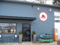
at McDonalds overlooking the Mississippi River, a short drive to uptown and a stop at the "American Pickers" shop. Disappointment! They were closed for filming, but we could take a picture and perhaps stop another time when we were in the area. You can check them out at their website www.antiquearchaeology.com. or watch on History Channel on Monday nights.

Along the bank of the river is the Buffalo Bill Museum and the River Pilots' Pier with the Lone Star Steamer to tour.

William F. "Buffalo Bill" Cody's life of legend started in 1846, the year he was born near LeClaire. Cowboy, Pony Express Rider, Scout, Marksman and International Star of his Wild West Show. A short video gives an overview of his early life. It was interesting to learn that he used glass balls and "birdshot" for his shooting exhibitions at the shows. Only a small section of the museum displays memorabilia from his life. Most of the exhibits show items used by the people living in the area over the past hundreds of years including the Sauk and Fox Indian tribes.

Interesting items we found:
  • LeClaire Manufacturing Company made a conversion kit to convert a push reel lawn mower to power mower with a Clinton engine.
  • A picture of a tug boat pushing a raft of clams to be made into pearl buttons at the local button factory. Tools used to make them.
  • Because of the absence of soft wood for lumber many buildings were built with limestone from several local quarries. Most all early construction used limestone for foundations. 50 and 60 pound hammers used!
  • A John Deere wrench and a Ford wrench that were included with early purchases of vehicles and tractors for repair and maintenance.
  • A charcoal burning iron and a gasoline burning iron from the 1900's. Can't imagine pressing clothes with these!
  • An 1873 American treadle sewing machine. A whole section of vintage clothes, quilts and handiwork with stitches that I have never seen before.
  • A baby cradle on wheels with a hook that was attached to a farm implement when mother went to field to work.
  • The family of James J. Ryan II, a 1920 graduate of LeClaire High School, donated his office to the museum. He attended Iowa State University and taught at the University of Minnesota. His nickname, "Crash Ryan", was earned because of he tested automobile safety equipment including a hydraulic bumper and seat belt designs. A Flight Data Recorder (Black Box) which he invented is on display.
  • A display featuring James B. Eads, a self taught engineer who listed LeClaire as one his hometowns. He is known as the man who mastered the Mississippi River because of the "jetty system" he introduced. Because he was in salvage, raising sunken boats, he learned how to navigate the rapids of the Mississippi. His gunboat designs during the Civil War were a precursor to the modern submarine. He is known for the Eads Bridge in St. Louis. The first bridge of a significant size using steel and the largest arch bridge in the world in 1874 when it was completed.
  • A cross section of the largest Rock Elm tree on record. It's height was over 50' with a crown that canopied an area measuring over 100 ft north & south by 80 ft. east and west! the "Green Tree" was a landmark at the beginning of the river rapids between LeClaire and Rock Island. It was a gathering place for pilots waiting for their boats to pick them up. All boats docked on the shore approximately where the Green Tree was, to change pilots and take on supplies before and after going across the rapids. It became known as the "Green Tree Hotel" when unemployed rivermen came to look for work. ( An inexpensive place to spread their blankets and cook their meals under the branches!) It died of Dutch Elm disease. It is also famous because of the formation of bark in the center. Tree experts believe it was so close to the river's edge that water washed up through the center and somehow the sun shown down through the hole, as bark needs both water and sunlight to form!
The Lone Star Sternwheeler

A large glass and steel enclosure, called the River Pilot's Pier, covers the only wood hull paddlewheel boat remaining intact that worked the Mississippi River. The "Lone Star" was built in 1869 and decommisioned in 1968. You can walk her decks as the Mississippi River flows past imagining what it was like to work the river! Climb up to see the huge pilot's wheel that steered the rudders, stand beside the paddle wheel, touch the equipment and pretend to shovel coal into the boilers. She carried and towed freight and immigrants that settled the midwest in it's early days. The last years she was used to operate a sand dredge, pumping 400 tons of sand an hour from deposits in the bottom of the river, load it into barges and take to Davenport to be used in construction, cement and other purposes. Today's tow boats navigate in a 9 ft deep channel with locks and dams but the Lone Star could operate in as little as 4 ft of water.
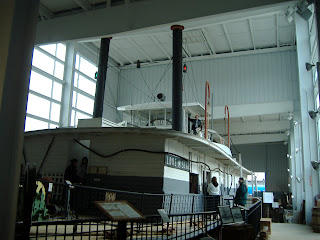
We see a lot of steamer trunks in antique shops, but most are just a large empty space inside. This is an original "carry-on" with wooden hangers and compartments intact!

The Mississippi River has always held a fascination for us. This museum gave us a picture of life along it's banks. But it is time to head back to our Prairie!

Thanks for traveling with us!

Prairie Schooners


Thursday, August 11, 2011

Lexington, Kentucky & Spring Hill State Park in Indiana


A small Winnebago, View, motor home to deliver to a new dealership in Lexington, Kentucky is our reason for being "on the road" this first week in August 2011. We did manage to beat the local raccoons to our sweet corn and enjoyed a couple of meals between picking up the unit and leaving! (Nothing can match the flavor of a freshly picked ear of sweet corn with butter and salt!!)

I-80 has very heavy traffic as we drive through the green Iowa countryside. We see small fishing and pleasure boats are in the Mississippi River enjoying the sunny, hot summer afternoon as we drive across the bridge into Illinois. Over the Illinois Ri
ver and an overnight stay at Bloomington. The top of the ferris wheel shows on the horizon behind the trees and the wind is blowing the midway noise our direction. Signs on the way for the tractor pull competitors all indicate that a county fair is in progress. Steak and Shake was within walking distance from the parking lot at Walmart. A new experience for us. The Portabello/Swiss Burger was super good. Fast service, but very noisy.

On the road early watching a beautiful sunrise! Colors spread across the par
tly cloudy sky as the large red ball slowly rises over the Eastern horizon. Thank-you, Lord! Through the pretty valley of the Vermillion River near Danville. Into Indiania. Still major road construction on I-465 around Indianapolis. South on I-65 to Louisville, KY. Leaving the flat farmland. Entering rolling hills, small farms, tall hardwood and pine trees, tiny corn and bean fields tucked in between the trees and dark brown wooden fenced pastures for the horses.

Over the Ohio River into Kentucky. East on I-64 through a tunnel, under metal and rock overpasses, curving through the tree covered Kentucky hills on a hot, muggy sunny day. Watching thunderheads form on the hori
zon. Dealer fill of gas. Arrived at dealer and got unhooked and unpacked just before it started to sprinkle. Back up the road to a Comfort Inn for the night. Oops, carrying in luggage in a downpour! Later the sun is shining as we drive to the Happy Dragon Chinese Buffet. A great meal, many options, tasty and fresh, good service, the chandeliers and filigree decorations create a quiet atmosphere.

When you look at the city map it is evident that Lexington streets are laid out like a wagon wheel. The streets go out from the center with two circles to join all of them. It is the Horse Capital of the World as proclaimed with a mural painted on the huge water tank. Streets are named for famous race horses. Stables and horse farms offer tours.
Lexington was founded in 1775, seventeen years before Kentucky became a state
. William McConnell and a group of frontier explorers were camped at a natural spring when word came from nearby Fort Boonesborough that the first battle of the American Revolution had been fought in Lexington, Massachusetts. In honor of the battle the group named their site "Lexington" By 1820, Lexington, Kentucky was one of the largest and wealthiest towns west of the Allegheny Mountains. So cultured was its lifestyle the city soon gained the nickname "Athens of the West."

The area gets it's nickname, Blue Grass Country, from the blue grass that grows over the limestone in the area. Makes excellent pasture for horses. The limestone was used to build dry-laid stone structures. The rock fences that have survived are one of the most identifiable and well-known features of this region. There is even a rock fence tour that you can take!

What is dry stone masonry? They are structures that are built without mortar. They rely on the skill of the craftsman, the forces of gravity, frictional resista
nce and have a slight flexibility that allows them to conform to foundation settlement without damage. Because the sides slope slightly inward, ground movement locks the structure more tightly together eliminating the need for a stiff concrete footing.

We drove south to Boone Station. Daniel Boone was one of the first white people to explore the area. When the settlement of Boonesborough became too crowded he and his family established Boone's Station in December 1779. At one time there were 15 to 20 families living in this area. By 1781, his claim proved to be invalid, but they continued to live there until 1791. All the families had moved away and it ceased to exist. A local farmer purchased 500 acres, built a large stone mansion which survived until the 1800's. Now some of the land has been given to the state. There is a picnic area and a walking trail.

Ft. Boonesborough, built to protect the area from the Confederate Army crossin
g the Kentucky River, was just down the road, but not open until later as was several of the other museums in the area so we drove east to Frankfort. Found the Kentucky Military History Museum, but it was closed. An interesting brick building in the older part of the town that is built along the banks of the Kentucky River. Entered the address for Rebecca Ruth Candy, but Gertrude (our Garmin) came up with no matches. Missed seeing how the original bourbon chocolates were made. Did drive a scenic route through the city to the Interstate.

North on I-65 in Indiana to Exit 19, then west on state highway #160 across Indiana countryside. No shoulder or ditch with the corn and bean fields and front yards at the edge of the road! Tree lined, curving around hills, up and down like a roller coaster ride! Through open acres with housing developments and small farms with Kentucky brown wooden fences around the pastures. Dark purple flowers that I later found out were Butterfly Bush similar to our orange flowered Butterfly plants. On the John Hunt Morgan Heritage Trail through Salem with a beautiful court house. This was the sight of Morgan's Raid in June 1863 during the Civil War. The furthermost north that the Confederate Army went in Indiana. They basically stole and destroyed supplies.

We discovered Spring Hill State Park on Highway 60 near Mitchell. A beautifu
l area with trails, fishing, caves, a stream for wading, picnic and camping areas. An Inn that has been featured in Midwest Living magazine. A pioneer village with a grist mill run by water power. A memorial to Virgil "Gus" Grissom.

We stopped at a picnic area to eat our lunch and were joined by two geese. They waddled up from the stream, stood and watched us, sat down and napped while we finished our lunch.

The center piece of the Pioneer Village is the grist mill that was originally constructed in 1817. We visited with the "miller" and learned some history and facts about the mill, which still works. They grind corn and sell the corn meal in 2 lb bags.

The mill is run by water that runs from a cave in the hills through a limestone viaduct built on limestone pillars (now
a pipe carries the water thru the viaduct because the kids were playing in it!) The water drops on top of a huge wheel that as it turns creates 7 rpms. Wooden gears made from hard maple convert that to 98 rpms to turn the huge grinding stone. The two quartz stones came from France weighing 3,000 lbs. They have grooves hand cut into the flat cutting surface. The one on the bottom has a square hole in the center and does not move. The one on top has a round hole and is turned by the wheel and gears. The stones do not actually touch. This allows the corn to be cut, not crushed. No heat is generated so no oil escapes making the corn meal flavorful, healthy and a long shelf life. The miller can control the distance apart.

The building is 3 stories high. Originally a storage area was on top floor for grain. It is considered a "rich" man's mill for being built out in the wilderness. The doors are thick and elaborately carved of walnut. In the late 1920's and 1930's the Civilian Conservation Corps (CCC) pl
ayed an integral part in the repairs and reconstruction of the mill and the rest of the pioneer village. Today the upper 2 levels are a museum giving the history of the area.

The mill is about 50 miles north of the Ohio River, which was the way to move goods on flat boats before trains and roads. At one time there were 2 ox trains sometimes with a dozen oxen to each wagon carrying corn meal south to the settlements along the Ohio and for shipment on boats down the river. A stage coach rout
e was set up to run through the area. Families moved there bringing men with the ability to make items necessary to the community. These buildings have been moved in and restored to show life at that time. Because they let their cows, horses and sheep roam free they built a limestone rock fence around their house. This was the origin of the phrase " house lot."

Interesting items and facts we discovered:
  • A pole lathe that enabled round objects to be made like cups, candle holders and rolling pins. A long pole on the ceiling would serve as the return spring for the treadle that turned the wood. Pressing on the treadle pulls on the string attached to the piece of wood you are cutting.
  • At the tavern you could get a meal for 25 cents and a bed for the night for 12 1/2 cents. Women and children slept upstairs and men slept downstairs on the floor. State law did not allow any more than 5 people to a bed and it is said that all guest had to use the same bathwater!
  • Burned lime or "slack lime has been produced here since the 1830's. A large deposit of limestone is located in the area.
  • Early teachers announced where they would hold classes and charged from 75 cents to two dollars per child per quarter to attend classes. He would also announce the "penalties he would inflict for breeches of discipline." They might include: two lashes with a beech stick for being idle. Three lashes for whispering and six lashes for fighting!
  • Church was summer "camp" meetings after the crops were "laid by" (planted and cultivated) and the oats was harvested. Tents would be set up in a woods and the people would gather for all day singing and preaching. Later churches were established by the Methodists, Baptists, Presbyterians, Lutherans, Church of the Brethern and Quakers. A new denomination, the Christian Church became strong in this area.
  • Early shoemakers were called cobblers or cordwainers. Cordwainers was derived from Cordova, Spain where fine leather for shoes & boots was produced. Cobbler was a more derogatory term at one time meaning clumsy workman. Men's and women's shoes were nearly identical in shape and design when made by early boot makers. Also because they were in a hurry to make them there were no left or right foot. Each shoe was identical. (one less thing for a child to have to learn!!) The development of 13 general shoe sizes rose with early measurements by barley corns (a grain of barley). Edward II in 1324 declared that 3 barley corns laid end to end measured 1 inch. Careful measurement than determined that the longest normal foot was 39 barley corns or 13 inches in length. Shoemakers traveled throughout the country and were welcomed in households. Besides making shoes for the family they were experts in sharpening edged tools, could cut hair or pull teeth, and were a great source of local news!
  • Courting candles were used when the young lady in a pioneer family had a young man that would call on her in the evenings. The holders were constructed so that the candle could be adjusted. If the father liked and trusted the young man, he set the candle as high as possible.If he would rather his daughter did not spend so much time with this particular man he would set it as low as possible. The young man had to leave when the candle went out!
History of the Mill:

The original mill was set up by a Canadian who had fought with the Americans in the War of 1812. Later he served as a guide for General William Henry Harrison becoming acquainted with the Indiana territory. He selected this site because it had continuous water supply from the cave. It also would not flood like a river. The limestone ledges for building supplies and the valley was protected by two steep hills. He built a cabin and a 15 foot square grist mill. His mill was so successful he even hired a miller.

Samuel Jackson was considered a "squatter" because he did not own the land. Two years later in 1816 President James Madison gave him a patent for 3 tracts of land. One is the village area now. This was awarded under an Act of Congress rewarding Canadians who had sworn Allegiance to the United States.

No one knows why, but 5 months later they left the area and went to Pennsylvania. They were doing well. More people were moving into the area. In a deed of conveyance Samuel Jackson "turned over his land, houses, outhouses, edifices and buildings; together with his woods, trees, fences, gardens and orchards" to two brothers, Cuthbert and Thomas Bullitt.

The Bullitt's home stood on the banks of the Ohio River and their farmland covered the area of what is now the city of Louisville, Kentucky. They replaced the small grist mill the one that is seen today.
Three stories with 3 1/2 foot thick walls. A 506 feet long flume supported by large stone piers (looks like an aqueduct) to carry the water from the cave. The stones were all hand cut.

Six years later they sold it and the village sight unseen to two brothers, William and Joseph Montgomery, wealthy merchants from Philadelphia for $20,000 at a time when the wage was 10 cents an hour! They built a tavern to serve the stage coach, a distillery, a cooper shop, a general store, a post office and added a saw mill that used a smaller water wheel. All of these buildings can be seen today with implements used at that time. After one of the brothers died in 1832 the mill and village was sold at a loss for $7,000. It is speculated that they sold because the mill walls were rumored to have had some cracks or because it was too far from Philadelphia to keep the younger brothers interest.

The railroad could not come to the mill because of the hilly terrain. People left the settlement to move near the railroad. Most of the corn meal was sold in the south and Indiana was Union during the Civil War so markets were closed. Dependable steam grist mills could be set up anywhere so people did not have to come to Spring Hill anymore. All of this led to the decline of the settlement.

Grissom Memorial

Gus Grissom was born in and attended school in Mitchell, Indiana. He was one of the original astronauts for Project Mercury, the second American to actually fly in space. The museum is just inside the park and there is a small fee to get into the park, but if you tell the attendant that you are only going to the museum they will let you in free. It contains memorabilia from his high school and college days, his space suit, the "Molly Brown" space craft, plus gives a very good history of the early space program. We remembered seeing take-offs and landings on TV, but did not know some of the background that is presented here.

Back to the Prairie

Comfort Inn in Terra Haute for the night. Great supper at Outback Steakhouse thanks to a gift card from our kids. A stop at Gander Mountain to find some fishing lures. On the road early for a drive on that long, gray ribbon of Interstate across Illinois to our Iowa Prairie!

Thanks for traveling with us,
Prairie Schooners


"


Wednesday, August 3, 2011

Delivery to Amsterdam, New York

This is our 70th motor home delivery in 7 years! Our plans were to pick it up Thursday, pack it up at the Prairie on Friday and take off Sat AM early to deliver on Monday. Dealers do not like deliveries on Sat. The dealer called and wanted it Saturday if possible. So, in 2 hours we pulled everything together and were on the road, that long, gray ribbon of I-80/90, headed east on a cloudy, muggy, hot afternoon in a 35 foot Winnebago Sightseer

Iowa is still a pretty green with wildflowers blooming in the ditches and medians. A rainbow of yellow and pink cone-flowers, purple vervain and bee balm, and white Queen Anne Lace. The bean fields are a rich green, an occasional gold oat field and rows of tall green stalks of corn with yellow tassel crowns. We did see the area where high winds had flattened the crops leaving them tangled and crooked.

Across the Mississippi River into Illinois. The crops are showing the effects of a very wet spring with wet areas not planted and shorter beans. We made it to the Flying J in LaSalle for the night. A very hot night!

A very early start on a cloudy day with a goal of 500 miles. The AC feels so good. A glimpse of pink clouds as the sun rises. Through Chicago with only a slow down for some much needed road construction or more politically correct "infrastructure improvement" on I-80. Into Indiana, a time change and in and out of sprinkles of rain on this cloudy day which is keeping the temperature from rising so high.

Past exit sign to the Studebaker National Museum and the RV Museum in South Bend. Will add them to our want to see list. More fields of corn, beans, oats and wheat . Farms with large barns & silos. Small towns and cities. Large trees form outlines for everything and line the roads. Past a field of gladioulas in bloom in a rainbow of colors.

A $20 toll paid before entering Ohio. After a half hour wait in line we pulled out our ticket for this state.. ( A patrol car with lights flashing went past on the shoulder, but we don’t know why the toll booths were closed down.) Ohio gets the award for the best Travel Plazas on the toll road! Past a County Fair in progress.

The miles are rolling by. Past acres of orchards near Toledo. The coast line of Lake Erie is not too many miles to the north. Through Cleveland on I-480 and I-271. Easy and not a lot of traffic. Acres of grapes. Paid another $20+ toll.

Across the 46 miles of the neck of Pennsylvania. Very rolling landscape with acres and acres of grape vines growing. We can see the clouds that form over the Lake. Into New York and back on the toll road. Still acres of grapes up and down the hills between the trees. Another County Fair in progress. Very frustrating reading our Atlas because the exit numbers are not the same as the miles! The Travel Plaza at Angola is our stop for the night. We made 580 miles today! There is a cool breeze coming in the motor home windows. Interesting plaza because we have to walk a covered bridge across the highway to get to the McDonald's. It is shared by both sides of the road!

A quiet, cool night's sleep! Moved most of stuff to the Saturn to make it faster at the dealer. 5:45 heading east into a beautiful sunrise. Another $11.80 in tolls as we skirt the edge of the city of Buffalo. Images of buffalo are painted on murals and miniature statues in the grassy areas along the edge of the highway. Exit to Niagara Falls and sign telling us that we are driving in the Erie Canal National Heritage Corridor. Fog is rising from the low areas. Deer are grazing. Farms are nestled in the hills surrounded by tree lined fields of crops which include vegetables.

Past the exit to Seneca Falls and Finger Lakes area, which we visited last year. Tall hardwood trees interspersed with low marshy areas. Tall mountains all around us. Huge white clouds forming above Lake Ontario are on the horizon. The flowers on the loosestrife plant form bright pools of purple in the grass. A processing and storage plant for onions and potatoes. Past Syracuse. Exit for the Salt Museum is on our "to see" list. Into the mountains with the Mohawk River/ Erie Canal beside us dotted with interesting old metal high span bridges. Garage sale signs and farmers markets remind us that it is Saturday. Last toll of $3.65 paid. (yes, all of these are reimbursed by the company and toll roads definitely make moving a large vehicle easier, safer and faster!)

Another motor home successfully and safely delivered! Fast check-in. Super 8 just down the road for us to check-in before spending the afternoon exploring!

Thanks for riding with us!

What did we find in the area? Watch for next blog!

Prairie Schooners


Thursday, July 21, 2011

Destination Medford, Oregon and Coast

The calendar says it is the middle of June, we are in Forest City picking up a 27 foot Winnebago Access motor home sold to a dealer in Medford, Oregon. After purchasing a new battery and tail light for the Saturn and a stop in Ames for a random DOT drug test we were on the Interstate driving past the wet Iowa landscape. Ponds of water in the fields, rivers running bank full, lush green everywhere, pink wild roses blooming, and large white windmills on the horizon. Signs show detours for I-29 due to the flooding on the Missouri River.

Our Interstate System: The General's Plan

I-80 looks like a long gray ribbon with multicolor stripes of cars & trucks winding up down the hills of Nebraska! The Challenge magazine published by Pilot Travel Centers had an article on the origin of our Interstate system. In the summer of 1919, just after the end of World War I, a convoy of 81 military vehicles left from the zero milestone marker on the edge of the White House'
s South Lawn, met the Lincoln Highway(soon to be known as U.S. Highway 30) in southern Pennsylvania and slowly made it's way west. Destination: San Francisco, California!

The mission of the convoy was to move from the Atlantic shore to the Pacific to better understand the challenges the defending American Army would face if the US were ever invaded and military troops and equipment needed to be moved quickly from one place to another. As the colonel glared at the military transport truck lying on its side like a beast of burden with a broken leg, one of dozens of accidents that slowed the progress of the convoy, it was clearly showing him just how vulnerable America was to invading armies.

The rules of the mission: The convoy would proceed under "war time" conditions a
s if an invading enemy force had damaged or destroyed roads, bridges, railroads and tunnels. The troops were under orders of self-sufficiency; they had to seek out their own housing, food and water. No supplies would be provided to them. There were more than 300 soldiers and officers including a young lieutenant colonel from Kansas by the name of Eisenhower, who went along as an observer "for the adventure of it." What Eisenhower witnessed shaped his view of the relationship between national defense and America's road system!

This convoy covered 3,251 miles in 62 days averaging speeds no faster than 6 mph and covering about 52 miles a day (We do at least 500 miles a day delivering motor homes). The convoy suffered an average of one accident every 14 miles on wheel-rutted roads that meandered across vast sandy plains or perilous mountain trails used by pack trains and horse-drawn wagons. It damaged or destroyed 88 bridges because of its weight

In 1943 Eisenhower was promoted to supreme allied commander in Europe during World War II. While in Germany at the end of the war, he observed Hitler's autobahns and was impressed with the efficiency of the well-designed and constructed German road system. Nearly four decades after his observing the convoy across the US, Eisenhower signed into law the Federal-Aid Highway Act of 1956 creating what is now known as the Interstate Highway System! (He was not the first person to conceive of a national highway system nor did he design the system, but he champio
ned a feasible plan and saw it through to fruition.)

The 47,016 miles of the Interstate Highway System equals only 1 percent of America's 4 million miles of roads, but that 1 percent handles 25 percent of all vehicular traffic annually!

Across Nebraska:
  • The Platte River is bank full.
  • Crops look good, so good the deer are having a feast!
  • Grain elevators dot the horizon and the sun reflects off the roof of the metal grain bins.
  • Flat plains with farmers making hay on the irregular shaped edges of their circle irrigated fields of corn.
  • Occasional flocks of wild turkeys feeding in the fields and pastures.
  • Grass & tree covered sand hills in the distance give us the feeling of driving through a valley.
  • The panhandle of Nebraska: rolling hills, pastures with cattle grazing, wheat fields with a yellow tint as it is ripening, occasional corn fields, cellphone towers, electrical transmission lines marching into the horizon, and wild flowers blooming in the pastures and median all under the wide open large blue sky!
  • Prairie dogs sitting beside their mounds.
  • Several large cattle feed lots growing steaks and burgers for us.
  • Oil wells & storage tanks
Into Wyoming
The rest stop at Pine Bluffs, Wyoming features the High Plains of Archaeology Museum with a trail featuring sites and artifacts from historic Wyoming. We are trying to make many miles today so did not check it out after we ate our lunch in the shade beside a picnic table. Sunny with a huge blue sky and 80 degrees.
Through the windshield:
  • Snow covered mountain peaks on the horizon.
  • Rigs set-up to drill for oil and natural gas.
  • Irrigation systems are spraying water even as we drive under a very dark rain cloud!
  • A semi on the frontage road hauling Ag Water--for cattle? for crops?
  • You know you are in the wilderness when the Interstate has signs telling you how many miles to the next services!
  • Strong side winds makes for both hands on the steering wheel and a noisy ride.
  • Antelope grazing in the pastures.
  • Climbing higher. Snow melt has pooled into ponds and streams keeping grass pastures green.
  • A variety of wild flowers blooming--splashes of white, orange, yellow, blue and purple!
  • Tall wooden snow fences standing like soldiers in company formation at attention waiting for the "blizzard" battle.
  • Tall white windmills lined up on the ridges with blades spinning in the wind.
Rawlins Flying J for the night. Since Pilot has purchased the Flying J's they are bringing in the Denny's chain of restaurants, but this one has not been set up yet. Our supper was pizza, salad, milk and ice cream from the convenience store. We were parked on a high ridge so the wind rocked us to sleep!

Back on that long, winding grey ribbon of I-80! Light rain this morning as we drive past open pit mining for a variety of minerals and over the continental divide. Through a tunnel. Flocks of sheep grazing. Snow banks in cliffs on north slopes of mountains. Driving through Evanston we see spring flowering trees (lilacs and ornamental pear) in bloom. Also tulips and iris. Spring is just coming to this area!

Over the corner of Utah
The last time we were on this road we were driving early morning in the dark with a full moon. New landscape for us: mountains are green with grass and shrubs with rust colored rocks protruding from the sides. Hazy in the distance as we drive into rain. Interesting pattern as a small spray of water from the wet pavement trails each car & truck. The grey ribbon of Interstate winds through the valley beside a Railroad track and a stream with fast moving rapids. Awesome!

The Wastach Mountain Range has snow covered peaks. The clouds are sliding up over the mountain tops as we drive in and out of rain.


We can see the Great Salt Lake reflecting the blue-gray of the cloudy sky as we turn north. Out of the city into a valley with pastures, hay and small grain growing. Dairy & cattle ranches, small businesses and small towns nestled at the foot of the mountains. The valley widens. Scattered ranches on the horizon. Acres of green pastures, tilled fields & wheat stubble. A shepherd's covered wagon is parked on the side of the mountain. Small rectangular shaped wagon with a rounded metal roof and a horse tethered beside it. Flocks of sheep in the distance
. Past the exit for the Golden Spike Natural Historic Site at Promontory, Utah. This is the place that the East and West Railroad tracks met.

North
Into Idaho
New signs along the road: Deer Migration Crossing, Dust Storm Area (we did see one on the other side of the road blowing away from us!) and Game Crossing! Through the
windshield:
  • Blue skies with white fluffy clouds float above us as we deal with the wind.
  • Acres & acres of just tilled irregular shaped fields as they lay across the contour of the rounded side of the mountain slopes.
  • The fragrance of new mown hay!
  • Fields of potatoes being irrigated.
  • Potato planting & harvesting equipment and storage buildings.
  • Over the Snake River--we will cross it several times!
  • Canals are dug at intervals through the countryside to move water from the river to the irrigation systems.
  • Large dairies have acres of "compost"--not fragrant--manure being aged to be bagged and sold for gardens!
  • Black rocks in piles and emerging from pastures must be volcanic rocks left-over from the volcanoes in the area.
  • Exit sign for the US Ecology Waste Site. Their website states," Idaho’s Grand View facility in the Owyhee Desert, treats and disposes hazardous waste, non-hazardous industrial wastes and low-activity radioactive material. The site's arid climate, deep groundwater, and favorable geology plus a state of the art multi-layer landfill liner system help ensure permanent waste isolation."
  • Exit sign for The Oregon Trail Interpretive Center at Three Island Crossing State Park on the Snake River at Glenn's Ferry. Oregon Trail immigrants knew this place well. It is one of the most famous river crossings on the historic trail. It was used until 1869 when Gus Glen constructed a ferry 3 miles upstream.
  • Pilot Travel Center Sign at Mountain Home--our stop for the night!
Because we will loose another hour at the Oregon/Idaho border we should be able to make delivery today, Lord willing. We will be leaving our long, gray four lane road for two lanes through the mountains, which will slow us down. Sunny with not much wind. Mountains are a black jagged outline to the east as the sun rises over them. Snow covered peaks in the distance to the west. This area seems dryer with the dessert to the south. Boise is a long town spread out in the valley. Miles of new road construction in the process with signs indicating that the "Project is funded with Carve Bonds."

Destination State--Oregon
This is like a traditional Jim & Shirley "road trip" only in a motor home as we turn onto the two lane highway driving through irrigated fields of onions, potatoes, hay, wheat, corn, and alfalfa in the valley at the foot of the mountains. A beautiful "quilt" in a variety of shades of green each outlined by the shallow irrigation ditches as we look down the valley from the highway! Through the Windshield:
  • Sign indicating that we are driving on the Oregon Trail.
  • Through the town of Vale. A stop on the Oregon Trail. The sides of the buildings have a mural depicting this stop.
  • Sign: Snow Area as we climb up a mountain pass, Vines Hill Summit. If it was winter we would have to put on chains to get through the snow.
  • Sign: Open Range--this is public land--As taxpayers we own it!!
  • Sign: Loose Gravel--not a good sign for new motor home deliveries because it usually means some rock chips. But in the mountains this is the way they fix highways. Only short distance this time.
  • Thanking the Lord for a beautiful sunny day and very good road curving around the mountains beside a fast running stream. Imagining what it would be like to be walking it or riding in a covered wagon!
  • Small village of Juntra. Several old cement block buildings, one with a metal jail cell behind it. A small brick church with a few houses, a restaurant and a motel.
  • Sign: Drinkwater Pass and Stinging Water Pass. Wondering what those names mean??
  • Corner posts for fences are a wire-fence cylinder filled with rocks.
  • Beautiful wild flowers scattered over the countryside like a rainbow! Shades of yellow, white, red, & blue.
  • Empty hay sheds waiting at the end of the fields for bales of new cutting.
  • Eagles flying.
  • Training stables & horse ranches.
  • The Paiute Indian Reservation.
  • Following a semi-load of bagged onions heading to market.
  • Lilacs blooming all over the town.
  • Regular gas is $4.00/ gal.
  • Oregon Experimental Range is 16,000 acres used by the U.S. Dept of Agriculture. Their mission is to develop agricultural and natural resource strategies that maintain or enhance inter mountain forest and shrub ecosystems. Currently they are researching the integration of beef cattle, range-land, wildlife, and watersheds. Your tax dollar at work!!
  • Snow covered Cascade Mountain peaks ahead on the horizon.
  • Pine Mt. Observatory exit. A place to go in the evening and watch the sky.
  • Acres and acres managed by the Bureau of Land Management----Oregon Badlands with ATV and OHV trails, shooting range, ancient junipers, volcanic vistas and sand underfoot. One area had roads to several reservoirs and lakes.
  • We missed a corner in Bend, but found our way through. Passed a sign in the parking lot--Local Morels for Sale. No price was printed!
  • Our two lane road now has little dots beside it on the Atlas--scenic, but not for fast traveling! We discovering what it is like to drive a motor home through the mountains!
  • Exit to High Desert Museum
  • Exit to Newberry National Volcanic Monument with information on the volcanoes in the area. A few miles south is the Newberry Crater with lakes. No time to stop.
  • Through the Winema National Forest with tall pine trees, meeting logging trucks, road construction stops and piles of black lava rock along the highway.
  • Driving along the edge of Crater Lake National Park we see snow banks. The roads leading into the Park are closed and covered with snow!
  • A call to the dealer gave us permission to park in their yard and check in the next morning. Another wrong turn making the dealers sign a welcome sight along with a motel a few blocks away!
Let's explore!
Back in the Saturn on a beautiful clear sunny day breathing in cle
ar mountain air and again trying to find our way. This time to get out of Medford! The city is beautiful with huge rose bushes in the median. Finally on Hwy #238, a scenic winding road, with pine covered mountains, going west. Strawberry fields with red ripe berries, grapevines, pear orchards, hay & vegetable fields, blackberry hedges with white blossoms growing wild along fences and flowers, flowers, flowers!

Found Hwy 199 south to the coast. Another two lane road with dots beside it on the Atlas! Tree lined with tall pines, snow covered peaks in the distance, small towns, and logging trucks. Across the border into California winding through the Siskiou Mountains with 20 mph curves, rocky ledges, tall pines and fast moving rivers.

Reserved a room at the Econolodge in Crescent City. Turned north on Hwy #101 to follow the coast into Oregon. Smith River, CA is the Easter Lily Capitol of the world. Acres and acres of them growing between Smith River, CA and Brookings, OR. This area has rich soil and temperate weather making the "White Gold Rush" industry that provides 90 percent
of the world's Easter Lily products.

The ocean is beautiful blue with white foam hitting the huge rocks along the coast. One area has farms where the farmers look out one window with an ocean view, walk across the room and view their pastures and fields. Sign: Olives for sale. Huge azalea bushes in bloom. Wild flowers, including blue spikes of foxglove, green fennel, and blackberries, are abundant in the ditches.

We stopped at the parking lot above the Whaleshead Beach, named from the shape of the rocks protruding from the water along the coast. (The
rocks are called "sea stacks." They are super hard and withstand the erosion that breaks up the other rocks.) Walking down the path surrounded with a lush growth of plants and flowers, to the black sand(because of the lava rocks in the area) covered with drift wood. The wind was blowing fog in across the tops of the trees. Awesome!

Nearly every place a creek or a river flows into the ocean there is a place to see the ocean and often a beach for you to walk. Bicycle trails are available and even mark
ed in the city. Flashing lights warn when a cycle is in a tunnel or on a bridge.

The fog was limiting our visibility so turned around, stopped at The Apple Peddler for our supper. Would highly recommend it for fresh and tasty food. Clam chowder was excellent. Back south to Crescent City with the fog rolling in for the evening.


A foggy damp morning to drive along the coast. Stopped at several beaches to walk and watch the surfers ride the huge waves. Heard the fog horn on the lighthouse that we could not see. Listened to the roar of the surf. Found many sand dollars laying on the beach. In and out of fog as we drive past and through the Redwood forest. Very tall pines with a reddish bark that turns to gray. A lot of decks and siding standing!


Signs: "Tusnami Hazard Zone" are scattered along the highway. "Deadly Sneaker Waves & Hazardous Surf" did not stop the surfers!

An Adventure as we head home:
Found a road, Hwy #36(with dots in the Atlas!) to take us East away from the ocean and toward Iowa. When you are in the mountains there are not many choices going your direction! A motel reservation in Redding was a w
ise move because it took us 5 hours to drive the 150 miles! An adventure!
  • The sign stated that this two lane road was not recommended for semi's.
  • Herds of Brown Swiss and Guernsey cows graze in pastures.
  • Winding our way through small towns and rural areas with pine covered mountains in every direction.
  • Wide and narrow valley views.
  • Through a forest of Redwood trees. We could reach out our hand and touch the trees as we passed.
  • Did meet some logging trucks and one semi load of hay bales.
  • Constant curves, climbing and coasting down the mountain with up to 10% grades. Some places no center marking.
  • The few small towns had populations of 50 or less with no gas stations.
  • Some road construction that we had to stop and wait for.
  • A couple of shifts in the road that could have been caused by an earthquake.
  • Spectacular views!
After a cool, restful night's sleep we headed to Lassen Volcanic National Park. Their website stated that they had 18 feet of snow this winter. They started clearing roads in May. We will see if it is open today.
  • A two lane road with no ditches or shoulders as drive beside ranch fences and front lawns in the towns.
  • Black volcanic rocks are scattered in pastures and yards.
  • Pretty vistas as we climb higher.
  • Park is closed because of snow.
  • We did stop at Vista Point in the Lassen National Forest. We could see the snow covered volcano peak in the distance.
  • Ponderosa and Jack Pines grow in this area. They grow a whorl of branches around the trunk each year. Count them for the age of tree. Six mature trees have enough lumber to build a house.
  • Snow covered peaks in both directions.
A cup of coffee at Susanville, CA as we drive out of the forest and into the desert with sagebrush and blooming cactus. Definitely cattle country. Taller snow streaked mountains in the distance. This snow melt is putting water into many of the "dry lakes" listed in the Atlas. The pastures are still green and fields are being irrigated.

Into Nevada
Back on I-80, that long gray ribbon that extends from coast to coast! Wind is blowing dust off one of the "dry lake" beds as we travel the 40 mile desert on the California Trail West that runs from Loveluck to Reno. It was a horror for wagon trains, but it was shorter. It was so hot that they would travel at night. The loss of livestock and lives were tremendous. There was no water available in this area. We stopped at a Rest Stop that had as its source of water one "old fashioned" hand pump, no grass, but did have shade built over the picnic tables.
  • Large bank of clouds spotted ahead. How far? Very hard to judge distances in the mountains.
  • An open pit mine.
  • A reservoir of turquoise water spreads out along the valley floor making a "recreation" area. It was created with a dam on the Humboldt River.
  • Processing plants for the minerals mined in the area & electrical power stations are scattered thruout the mountains.
  • Spent a frustrating night at the Super 8 in Elko. Phone service for local calls only and cell phone cut off as trying to make reservation for next night.
  • Sunny cool drive continues past mining company headquarters and supply depots. Some mines in this wilderness could be gold mines because Nevada mines the most gold in the US. Not large nuggets, but flakes that need to be processed from the rock.
  • West Wendover has huge casino/hotels rising up from the desert in a stretch beside the interstate. Nothing green. Just rocks and concrete!
Back into Utah
The Great Salt Lake Desert stretches out in front and all around us. No green. Only white sand with occasional areas of water from the snow melt. Exit to the Bonneville Speedway. Exit to the Utah Test & Training Range and the Dugway Proving Grounds. Large piles of salt at the Morton Salt company.

Great Salt Lake on our left is a beautiful turquoise with snow covered mountains as a back drop. We heard on the radio reports of flooding in areas of the city due to the unusually large amounts of snow in the mountains and saw water on the shoulder of I-80.
Past the world's largest open pit mine, Bringham Canyon Mine has been mining copper since 1906.

Winding thru the Parleys Canyon. Every mile is a "Kodak Moment!" Some green grass, shrubs, trees and covered with wildflowers with signs pointing to recreational areas. Always another range of mountains in sight with a pass to get over or a valley to get through! Like life?? God provides strength and wisdom for both experiences when we trust the shed blood of Jesus for our faith!

Back to Hwy#84 north--rewind scenery!
This is where we took #84 North into Idaho on way out so we can "rewind" our scenery!


About an hour west of Rawlins, WY we were stopped by an accident up ahead on the interstate. A semi tractor and the mechanics truck helping it were both burning. Traffic both ways was stopped for over 2 hours while they let it burn. It was so isolated it took too long to get fire engines to the area. No one was injured, but the semi was just a small pile of steel along the side of the road. What do you do for 2 hours stopped on the Interstate? We visited with the people waiting with us and checked with the motel to be sure we had a room!

Gabby's restaurant in Rawlins is the popular place for the locals to go. We picked the wrong item from the menu. Our chicken was so small you "almost had to take the egg shell off before frying it!" We looked around and saw some awesome pastas and burritos! The rain cloud that had been threatening moved to the east and gave us a spectacular rainbow to view out of the restaurant window. The bulletin board had a schedule posted for Friday night movies in the local park. A costume contest for the theme of the movie was included!

Finished our trip on the long gray line thru Nebraska, past the metal sculpture of a wolf howling to the sky on the butte above the town of Potter, NE, a stay in York, under the Arch that spans the interstate, and across the flooded Missouri River into Iowa. Even in a fog Iowa is looking great. The lower gas prices are welcome after the $4+ out west. Interesting to see the blades of the windmills disappear in the fog and then reappear. The metal pheasant sculptures near mile marker 50 welcome us back.

We do miss the clear mountain air! So thankful for the opportunity to enjoy our adventure and so thankful for our home on the Prairie!


Prairie Schooners


Saturday, May 21, 2011

Edmonton, AB

On a rainy cold early morning the last week of April, we drove north to Forest City to pick-up an Itasca Ellipse motor home to deliver to Edmonton. It is definitely a home on wheels. A Freightliner chassis, diesel pusher with a 150 gal fuel tank! Yes, it took us nearly $500 to fill! 43’ long, 101” wide, 13” high with both entire sides able to slide out! Complete with dishwasher, washer & dryer, central vac, fireplace, big flat screen TV, 2 bathrooms, an outside entertainment unit, and an inside infotainment unit with GPS! It looks like a home inside with the silver/green color scheme and glazed cherry cabinets. The wood trim on ceilings imitated the look of exposed beams.

Rain, wind and water sitting in fields, ditches and median. Lakes are bank full. Rivers are flooding. Thru Minneapolis to I-94 west. Small towns, large farms, dairies, partial stacks of bales, grain elevators, dot the drenched landscape that is trying to transition from winter to spring!

Into North Dakota staying at Fargo at a Petro Truck stop for the night! The odometer is in km so we dig out our metric measurements knowing we will need them for fuel prices and to read signs once we cross the border. (Yes, grandkids, learning math is important!)

We are greeted with a partly cloudy blue sky and no rain. Driving through the Red River Valley, which is flooding, we see acres of flat farm ground with small towns and grain elevators. Some of the ponds are still covered with ice. This is also “pot-hole” country with many small land depression in fields filled with water. Lines of trees planted as windbreaks still have snow banks at their trunks looking like they are still “tucked” in their snow quilt for the winter!

We left the interstate to take US#52 to the border crossing at Portal. The two-lane highway makes a red diagonal line across the center of the North Dakota State map. We meet and pass many over-sized loads of various kinds of equipment. Some are being imported or exported to Canada. Some are just moving local farmers equipment. One of the largest was a truck carrying two 27’ bases for grain bins!

View from the windshield:

· The highway runs parallel to a Rail Road track. A crew was working on the tracks. As we drove north trains were backed up waiting.

· Every 10 or 15 miles is a small town with a grain elevator surrounded by acres of farmland.

· The flooding caused water on the edges of the road in a few places. We saw a boat sitting beside a flooded gravel road, a house on an island with a bright blue port-potty in front and sand bags around buildings.

· Grass covered hills still brown from winter with “dollops” of white snowbanks scattered on north facing slopes.

· Cattle grazing with small calves at their sides.

· Very interesting names of towns: Fessenden, Velva, Carpio, Pingree, Voltaire and Adamore. Many had signs indicating a local museum. Would be fun to have time to stop and visit each.

· For miles we drove through grassy hills with white stones on the slopes outlining the numbers of the year of graduating seniors! A project that would take a lot of time and effort since the hills were isolated from roads and the rocks would have to be collected! Do we call it “green graffiti?”

· Grasshopper shaped oil wells. Shiny new ones. Drilling rigs. Hopefully help with reducing our gas prices???

Saskatchewan, Canada

This province of Canada is mainly associated with the prairies and grain growing, but the terrain is far from flat and barren. It also has a rich reserve of heavy oil and over half the world’s known recoverable reserves of potash along with uranium mining, pulp and paper production, commercial fishing and trapping, manufacturing and construction industry. Again we drove many miles of two-lane provincial highways before getting to the trans-Canada auto route, another red diagonal line on the atlas map!

Through the windshield:

· Oil wells & drilling. Pipes being laid. Miles of oil rig and mining equipment sales and rental business.

· Large cranes working on the horizon behind huge piles of sand. An open pit Potash mine. (We would have received train loads and truck loads of this potash when working at the retail fertilizer outlets here in Iowa) Acres and acres with piles in rows of left-over sand from the mines. The older ones are grass covered low hills.

· Then flat acres of farm ground with small towns dotted every so many miles. Each has a grain elevator next to the Rail Road track. Some large seed companies with their bins and legs. The farmers have rows of small grain bins instead of the large ones we see here in Iowa. We think this is because they grow seed and have to keep each variety separate.

· Instead of a sign stating “Historical Marker” they have signs: “Point of Interest!”

· The roads are rough.

· Water everywhere there is a low spot because of the snow melt.

· Through another rain storm. We seem to have rain at least half of every day we are on the road.

· Moose crossing signs. One dead moose in the ditch.

· Interesting that Saskatchewan has signs printed only in English where other provinces are both French and English. But meters and kilometers instead of feet and miles!

· Saskatoon, the “City of Bridges” with six bridges spanning the South Saskatchewan River also had the Flying J for our overnight stay. It was a welcome sight after a long day driving through an area with very few places to park an “elephant!” We turned onto the Yellow Head Highway #16 that crosses Canada. Named because it goes through the agriculture area where acres of wheat is grown.

· Blackstrap Mountain ski resort sign seemed out of place in this area, but it is a man made mountain built in 1971 for the Canadian Winter Games with a main ski run of 1400 ft.

· When talking to a waitress in Denny’s about time difference she explained that the farmers said the cows do not change time so therefore this province does not change time! No daylight savings time for them!

· It is pretty with the sun rising and making the fields of harvested wheat stalks glow. But thunder and lightening and black clouds ahead for our half day of rain?

Alberta, Canada

Again we see many oil wells, drilling, oil field equipment for sale, rent and manufactured.

Past a town, Vegreville, with a sign advertising “largest pysanka.” A pysanka is an Easter egg decorated using a batik method. This is a Ukrainian tradition. This town is in the center of Alberta’s Ukrainian settlements and has the world’s largest known Easter egg. It is 25 ft by 18 ft made of aluminum and decorated in gold, silver and bright colors! On another trip we had visited the Ukrainian Culture Center just east of Edmonton. It is a museum set up as a community with the buildings of the early settlers.

A stop at the Flying J for the dealer fill, a stop at the Truck/RV wash for the dealer wash job and then to the dealer. We found out that this motor home was for the owner of the dealership. This was the greatest display area we have ever seen at a dealership. The walls were a mural of snow covered mountains, tall pine trees, a lake and stream that went all around the area. The RV’s were set in a circle with artificial trees of all sizes, a couple stuffed deer and a life-sized bear. A fountain in the corner gave you the feeling of hearing the mountain stream! The offices around the edge were all covered with a log-cabin design paper giving you the impression that you were surrounded with buildings! It was good that it was a pleasant place to wait because it took an unusually long time to be checked in!

Thanks to Gertrude, our Garmin, we found a motel a few miles from the dealership with a restaurant attached. A cold, damp wind made the warmth of a room welcome!

The Thai Orchid Restaurant was a new experience for us. It is similar to Chinese cuisine. Instead of a fortune cookie we received a piece of tamarind flavored candy. The warm green tea with real leaves was soothing to my sore throat. Not fun traveling with a sinus cold!

We asked the young lady putting out breakfast at the motel if this damp, cold weather was typical for spring. She replied that every year people complained of a cold spring, but this is normal and probably will have a couple more snows before it warms up!

Our plans are to drive south on Highway 2 through Red Deer and Calgary, then take Trans Canada #1 to Medicine Hat driving south from there to Wild Horse to cross the border into Montana and take scenic route #2 east to North Dakota. We knew the mountain roads around Baniff would be still closed with snow.

A variety of landscapes along the Hwy to Calgary. Rolling hills, farm land, pasture with stacks of round bales, farm & ranch buildings, lakes with ice, pine trees are the only green on the brown landscape, white bark of the birch trees accent the forests, oil wells, and towns and cities with malls. In the distance we can see the snow on the side and peaks of the Rocky Mountains. Calgary’s downtown skyscrapers are outlined against the horizon as we enter the outskirts of the city. A dusting of snow left-over from last night snow shower glistens in the sun.

East on Trans Canada #1 through open acres of fields and pastures. It feels like we are driving along a ridge because we can see for miles! Cattle grazing. The farmers stack their large round bales on end in 2 rows, then layer 2 rows on their side, and top with 1 single layer down the middle! The moisture slides off the round sides and preserves the hay for a longer period of time. Prairie pasture architecture!

Huge farm equipment sitting in the fields ready for seeding.

The fields have their fall harvest combine quilt! A pattern with long strips the width of the combine in light and dark shades as the combine tips the wheat stubble different directions.

Long, fast moving trains on the horizon.

Acres of grassland hills, canals to run water & irrigation rigs, but mostly oil wells and cattle grazing. Canada is dealing with energy—many, many new oil wells and new storage terminals.

A Super 8 in Medicine Hat for the night. The Discovery Channel had a segment showing how they make Winnebago motor homes in Forest City, IA. It has been many years since we toured the plant so enjoyed seeing them make what we deliver!

We heard on the news that Montana was dealing with flooding along the Milk River beside the scenic highway we had planned to take. Changed our plans and continued east into Saskatchewan planning to cross the border at Portal.

Saskatchewan, Canada

The signs tell us that we are traveling though the Canadian Badlands. It is an area of sandstone buttes, sharp cliffs and rough-hewn caves among the grass covered hills. In the late 1800’s, this area was a haven for cattle rustlers, horse thieves and stagecoach robbers because of its forbidding terrain and the proximity to the United States border.

Today there is a Buffalo range, oil & natural gas fields and cattle range.

At Moose Jaw we head south on Hwy #39, another red line going diagonally across the atlas map. This one we will remember for a long time! Shortly after turning we see snow in the air. Then accumulated on the ground. Then blowing across the highway that is snow covered. (Later we heard that the wind was blowing up to 80 mph and the storm had started at 3 AM with heavy rain.) Following a caravan of semi-trucks we slow, then stop, then creep along past vehicles and trucks in ditch or nearly in ditch driving on packed snow up to 8 inches deep with “potholes” where surface of pavement is showing.

Several hours of this before we get to the town of Estavan. Only town with a motel! We did manage the unplowed city streets and got the next to the last room at the Days Inn! No restaurants were open. Half of the town was without electricity. But the motel did serve cold sandwiches and a salad in there restaurant by a few of the employees who made it in to work. We were so thankful for a warm place out of the storm and for Jim’s driving skills in the blizzard! It had taken us 5 hours to go 140 miles.

We started late in the morning. The sun was shining, no wind, but the road was still a washboard of “potholes” and snow/ice covered all the way to the border. Back in North Dakota with very little wait at the border. Most of those crossing were trucks. We heard on the radio that most of the towns in north west North Dakota were still without electricity at the end of that day! On a scale of 1 to 10 it was considered an 8+ storm!

The rest of our trip seemed very uneventful after that day!

Thanks for traveling with us,

Prairie Schooners